NORMAN PARLEY
In the year 1086, William the Conquerer turned his orderly mind to the better assessment for taxation. To this end, his Commissioners travelled through the land, to obtain information from responsible witnesses on the spot, as to the condition of every part of his realm, with certain exceptions. From their enquiries Domesday Book was compiled, and thus we have our first documentary evidence regarding West Parley.
The following is a translation of the entries concerning the two manors or estates into which West Parley was then divided.
"Radulfus de Creneburne holds Perlei. Brisnod held it at the time of King Edward (the Confessor) and it was taxed as two hides. There is land for two ploughs, which are there and five villiens, and four bordars, and two slaves, and 15 acres of meadow. The pasture 1 league long and 7 quarentens. The wood four quarentens long and 1 quarenten wide. It was and is worth 30 shillings."
"Azelinus holds Dodesberie of Walleranus the Huntsman. Godwin held it in the time of King Edward and it was taxed as one hide. There is land for one plough which is there, and four bordars, and 7 acres of meadow and 6 acres of wood. The pasture half a league long and 5 quarentens wide. It is, and was worth twenty shillings."
We see that the former Saxon owners were dispossessed by Normans, otherwise there is not much apparent change, the system and conditions of land tenure remained the same, but the feeling that they were a conquered race bit deep into the Saxon's soul and was not forgotten for generations.
The Domesday entries require some explanation
"A hide" was the unit of assessment for taxation, that is to say, it denoted the taxable value of an estate rather than its area.
"Land for one plough" was 120 acres of arable land.
The ploughs, with their teams, 8 oxen to a plough, were there, so the necessary "outfit" was complete.
A villein was a superior peasant (the word has undergone a sad change in meaning), he held a homestead and perhaps 30 acres of arable land of his own, on condition that he took his share in the cultivation of his lord's land or demesne, and performed other services according to custom.
A bordar was a cottager, with a smaller holding and he, too, worked partly for himself and partly for his lord.
A slave owned no land.
No peasant could leave his lord's service without his permission.
The lord, too, had his duties to perform; to furnish so many armed horsemen when required, to defend the royal "burghs" or castles, and to repair bridges, besides, of course, paying his taxes.
The Domesday league was 1½ miles.
A Quarenten was 40 poles, i.e. 1 furlong.
The Domesday acre was equivalent to the present statute acre.
We can get a fairly complete picture of Parley in the 11th Century, and its appearance probably did not alter greatly until the 16th Century, when the decay of the old system of farming was completed by the open fields being enclosed and parcelled out into farms, which with their hedgerows completely
changed the face of the countryside.
The peasants mentioned in Domesday were probably all heads of families and taking the average family at a low figure, the population of Parley would have been 50 or 60, and of Dudsbury, 20
At West Parley the Church was in its present position with the priest's house near by. It is improbable that the lord lived in Parley as he held other manors, but the Manor Farm under his Steward or head villein was probably on the site of Church Farm. Straggling down Church Street were the cottages of the peasants, with good mud walls and snugly thatched, each with its sheds, garden and paddock.
Then beyond the houses the wide and open arable fields, divided into long narrow strips, each an acre or half acre, separated by a "balk" of unploughed turf. These strips were grouped into "shots" as best suited the lie of the land, sometimes leaving a three-cornered piece, which could not be cut into a strip, which was called a "gore acre"(a)
A small field of this shape near the Rectory, is called "Gore Acre" to this day.
Where the ends of the strips of one shot abutted on the side of another shot, it was known as a "butt". The field south-west of Wood Town Farm is known as "Butts"(b)
The lord and the peasants each held so many of these strips, but the strips of each man were not together, but scattered throughout the field. This ensured that no man had all the best land, and was not so inconvenient as it seems, as several peasants had to combine to furnish a full plough team.
By the River were the Meadows, where each man owned his due number of strips, marked by posts, where after the hay had been carried, all could turn their beasts for pasture. Everybody's Mead, still divided in this way, can be seen East of the New Bridge, and is a most interesting survival.
The manorial Wood provided firing and timber for the requirements of the village, and the Heath turf for fires, which was regularly dug in the memory of many men still living.
The pasture was two miles away over the Heath, in the valley of the Moors River and Uddens Water; nowhere else can we find sufficient room for the Domesday measurements. This situation explains why the parish at this point suddenly increases in width from half a mile to two miles. This distance seems inconvenient, but when asked, a Parley farmer remarked to the writer;- "Don't
you think that I would drive my cattle two miles if I could get free pasture?"
There was probably also a small pasture near the Manor Farm, and when the crops were carried, cattle were grazed on the stubble fields.
The rights of all were upheld at the Manor Court, when the boundaries of the fields were recited, abuses, such as unlawful encroachments, checked, and the village officials chosen - the hayward who saw to the hedges and fences, the herdsman who drove the cattle to the common pasture two miles away, and others as might be necessary for the good ordering of the village. Then were paid the customary dues, such as a heriot of the best beast, when a man died and his land passed on to his son or widow - death duties are no new invention.
The village was practically self-supporting and this implies a vast amount of work. Consider, for instance, how much it would add to the labours of a present day household if all their clothing were made at home, from shearing the sheep or retting the flax to making the buttons.
But life was not all hard work and heavy service; the Church enjoined and enforced a surprising number of Holy Days, and we gather that they were not entirely devoted to religious exercises.
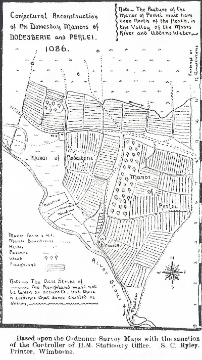
It is rather surprising, how, after eight and a half centuries it is possible to reconstruct with tolerable accuracy the "lay-out" of the Norman Manors, and they probably existed in the same form for perhaps three centuries earlier. The accompanying sketch does not claim to be more than conjectural, but as far as possible it follows the Domesday description on the one hand and the lie of
the land on the other.
Space does not allow the writer to set out in full his arguments in support of his reconstruction, but one or two remarks may be of interest.
The Lady of Lydlinch, probably in the 14th Century gave two thirds of the tithes of Dudsbury Farm to the Rector of Lydlinch, who still receives them. In 1839, when tithes in kind were changed to a money payment, the Tithe Commissioners placed the Tything of Dudsbury in a separate schedule of the Terrier(c) from the rest of West Parley, to shew what sums were to go to Lydlinch. It seems probable that the Tything of Dudsbury of 1839 was exactly the same as Duds Bury Farm of the 14th Century and possibly the same as the Manor of Dodesberie on the 11th Century. The boundaries thus given exactly corresponded (except at one small point) with those that the writer had already worked out from other data as the limits of the Domesday Manor.
Again, notice the field called Wood Town(d) Ground, the curious extension (or
"leg" as it is called locally) is approximately a furlong long and 4 poles ("lugs" locally) wide. It is one of the original strips, probably preserved to give access from the lane to Wood Town Ground when that field was enclosed and no longer formed part of Wood Town Farm (as by its name it must have once). This strip gives a clue to the plan of the neighbouring strips and shots. Then there are at least three possible sites for the manorial wood in West Parley, which fulfil the conditions of "4 quarentens long and 1 quarenten wide" but the names of Great and Little Wood and Woodtown Farm give the most probable site. That there was a wood there once is certain but the question is whether it had been felled and cleared before the Domesday Inquest.
The acreage of ploughland shewn in the two manors agrees very closely with the Domesday acreage.
Notice also, how the existing footpath from Longham to West Parley deviates from the direct line and, North East of Dudsbury Camp, bends to strike the main road which it follows for 100 yards and then turns back to resume its original direction. If we realise that the path was for the convenience of the
inhabitants of Dudsbury Manor Farm, which was almost certainly situated in the position shewn, with roads, tracks or paths radiating to every part of the Manor, the real reason of the apparently meaningless "kink" is plain
(a)In dress-making a triangular piece of cloth is called a "gore". The term is also used in heraldry
(b) As a butt was a convenient and safe place to stand a target (especially on a hillside where the bank of a linchet formed a "stop-butt") the term became
applied to the mound behind the target on an archery range and later on a rifle range.
(c) A Terrier is a book in which landed property is registered and described.
(d)The Anglo-Saxon "tun" meant primarily an enclosed piece of ground, then a
dwelling and only later a collection of dwellings