PREHISTORIC PARLEY
NEOLITHIC AGE The earliest vestiges of human occupation in the Parish are worked flints of the Neolithic or Later Stone Age.
Roughly parallel to the present course of the river, and some eight to ten feet above the flat meadows, is a well defined "River Terrace", which marks the level of the valley bottom before the river had cut its way down to its present level. This terrace may be followed for some miles along the river and must have been caused by some change in the physical conditions, such as a slight rise in the general level of the land above the sea, or a greatly increased flow of water.
It is probable that the passing of the last Glacial or Ice Age resulted in both these changes. The land was relieved of the immense weight of the ice, and the melting of the glaciers released vast quantities of water, which not only scoured out the valleys but also caused a damper climate and a heavier rainfall. It is true that the actual glaciers did not reach south of the Thames but the
effect of them and their disappearance must have been widespread.
It is on this River Terrace and on the level ground to the North of it, that the traces of Neolithic man are most abundant; scrapers, borer's, saws, and arrowheads of various types, as well as rough flint cores from which flakes were stuck, are found throughout its length.(a)
These Neolithic folk were of the so-called Mediterranean Race, slightly built, of middle height with dark hair and eyes, and long-shaped skulls.
In Britain,the Neolithic Period is considered to have lasted some 3,000 years, from B.C. 5000 to B.C. 2000, and was one of steady, if slow progress.
BRONZE AGE About B.C. 2,000 a new race appears, thick-set darkish people with round skulls. They seem to have overcome, but not exterminated the long-headed Neolithic folk. They buried their dead chiefs in their typical round barrows.
We have several good examples of these in West Parley. Mag's Barrow, Ralph's Barrow and Parley Barrow, of which the last is perhaps the best. It is circular in plan and is surrounded by a ditch 12 feet wide and 2 feet 4 inches deep. The circumference of the outer edge of the ditch is 140 yards. The height of the mound above the ground level is 9 feet 6 inches. 50 yards S.S.E. is a small
"satellite" barrow, very inconspicuous, without a ditch,rising only 2 feet above the ground and 39 yards in circumference.
They introduced the use of bronze tools, but the metal was rare and treasured, and flints continued to be used for many purposes.
IRON AGE Then, about B.C. 700, the first comers of a new people appeared; these were of the so−called Nordic race; big, fair men with blue or grey eyes, who spoke the Celtic tongue.
They brought with them iron weapons and tools, and to them are due many of the earthworks known as "Camps", "Castles" or "Rings" in Dorset, though it is quite possible that they merely improved the defensive positions made by earlier inhabitants.
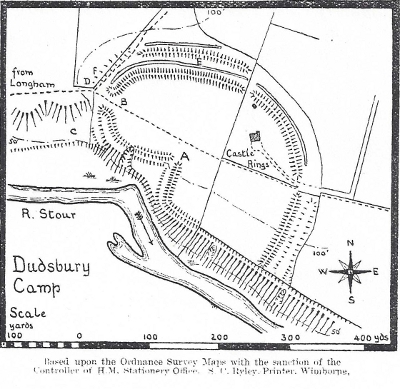
We have a good example at Dudsbury(b) partly in our own Parish and partly in Hampreston.
Here, the high ground falls abruptly to the river, some 70 feet below, and slopes less steeply to the East and West; to the North it is connected with the heathy plateau between the Stour and the Uddens Water. It is naturally an admirable position for defence, and was skilfully improved to enclose an area of about 8 acres.
On the river side, the ground appears to have been "scarped" or steepened with a rampart on the crest and a defensive terrace farther down the slope.
On the landward and naturally less strong sides is a double rampart and ditch, roughly semi-circular in plan, the inner rampart being still some 11 feet above the ground level. The ditches are cut through the sandy and gravelly surface soil into a stratum of clay, so that, in some places, they still hold water. The outer rampart and ditch,have suffered much from levelling for agricultural purposes,but can be traced through-out their length.
An interesting feature is the entrance. A (see plan) called the "Water Gate" by
Warne in "Ancient Dorset". Flanked by the ramparts on either hand it would be a difficult passage to assault. It is most probable that the River has encroached since the Camp was made, and that the slope below the entrance was formerly less precipitous.
The Northern and Eastern entrances are modern, but the Western entrance "B" is evidently ancient. It was probably approached from the natural terrace C, up the steep gully and then with a right angled turn between the two traverses which project from the inner rampart and which form the inner entrance.
This approach would force an assailant to expose his unshielded right side to the shot of the defenders.
In 1921, excavations under the direction of Mr Heywood Sumner F.S.A. were made at D, which proved that the outer ditch originally extended to the edge of the steep slope, so that the approach cannot have been along the way of the present footpath from Longham.
Mr. Sumner also excavated the inner ditch at E, where under 4 feet of peaty leaf-mould, which in the course of time had partially filled the ditch, were two sherds of Iron age pottery. These sherds are of a very dark brown colour, with a smooth surface, pitted in places.
A further excavation at F shewed that the outer ditch was here 4 feet 6 inches below it present level. Strangely enough, some sherds of mediaeval pottery were found in this ditch.
To the Celtic inhabitants, who were known to the Romans as the Durotriges, we owe the name of our River, the Stour, that is, "ys dyr", the great water. We can imagine it winding through the swamps and pools of the undrained valley, covering the meadows and being, as it is even now at high flood, a great water.
No traces of the Roman occupation have been found at West Parley.
a A collection of flint implements found at West Parley by Mr T. Dayrell-Reed, has been presented by him to the Dorset County Museum, Dorchester.
b See Proceedings of the Bournemouth Natural Science Society, Vol xii